RESULTS OF MONITORING STUDY OF BURNS HARBOR
BREAKWATER
David D. McGehee, P. E.
Abstract
A monitoring study was conducted by the US Army Engineer Waterways
Experiment Station (WES) of the breakwater at Burns Harbor, Indiana, at the southern end
of Lake Michigan. The breakwater, which was designed and built in the 1960's using two and
three-dimensional physical models, has required extensive maintenance over its lifetime.
The purpose of the study was to evaluate the efficacy of the design process and provide
data for a planned major rehabilitation of the structure. The study collected data on
incident and transmitted wave conditions, stone stability, and foundation performance.
Wave transmission was measured during conditions exceeding the original design wave
height. The results are compared with design assumptions and predicted performance
characteristics. The data were also used to identify damage modes, select design
alternatives for the rehabilitation, and calibrate more recent physical model studies
conducted at WES.
Introduction
The Monitoring Completed Coastal Projects (MCCP) Program was
established by the US Army Corps of Engineers in 1981 to evaluate the performance of the
Corps in planning, design, construction, and operation and maintenance of selected Civil
Works coastal projects. The program's objective is to acquire information through
intensive monitoring of coastal projects for improving:
a. Project purpose and attainment
b. Design procedures
c. Construction methods
d. Operation and maintenance techniques
Burns Harbor was nominated for inclusion in the MCCP by the US Army
Engineer District Chicago (NCC) in FY85 because of the potential for solving site-specific
problems and improving general procedures for application at other sites. The monitoring
effort and its documentation was a joint effort conducted by the WES Coastal Engineering
Research Center (CERC) and the NCC between 1985 and 1994.
Site Description
Burns Harbor, Indiana is located on the southern end of Lake Michigan
(Figure 1). The configuration of Lake Michigan exposes the harbor to significant wave
energy from the northern quadrant. Maximum fetch is about 300 miles, to the north. Water
levels fluctuate seasonally more than a meter due to regional precipitation and nearly a
meter during storms from wind setup/setdown.
Active glaciation in the Pleistocene caused radical variation in lake
levels and a wide diversity in depositional patterns around the Great lakes. The result in
the vicinity of Burns Harbor is an inhomogeneous distribution of sand and gravel lenses in
a matrix of both stiff and soft clays. The natural shoreline consists of high dunes of
medium sand. The lake bottom is covered with fine sand; slopes are on the order of 1:100
offshore of the harbor.
Harbor Layout
The federal project consists of an L-shaped breakwater with a western
arm 1200 ft long and a northern arm 4640 ft long (Figure 2). A cellular sheet pile
extension connects the western arm to the shore. The depth of the toe of the northern arm
ranges from -30 ft to -41 ft Low Water Datum (LWD). The authorized project depth is 30 ft
in the entrance channel, and 28 ft in the harbor.
The interior perimeter of the harbor has both riprap revetment and
vertical steel sheetpile sections. The east harbor arm is bordered by the Bethlehem Steel
plant; the west harbor arm flanks the National Steel Corporations mill; and the central
portion of the harbor, or north wharf, is occupied by the Cargill Grain Co. facility. The
Cargill grain dock is a rectangular sheet pile quay projecting outward from the adjacent
riprap-covered fill.
Breakwater
The breakwater is a multilayer rubble-mound structure with two layers
of randomly placed Bedford limestone armor (W stone). The parallelepiped, cut stone armor
units, which range from 13 to 16 tons on the trunk and from 15 to 20 tons on the head, are
typical for coastal structures in the Great Lakes, but the two layer random placement was
unusual at the time of its design (Figure 3). A high core design with laid-up placement of
a single layer of armor is more typical. Burns Harbor was the first breakwater of its kind
built in the Great Lakes.
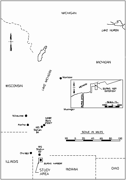
Figure 1. Location Map of Burns Harbor Breakwater |
Project History
The project history reveals a harbor viewed as a
"problem" by port users from an operations perspective, and by NCC from a
maintenance perspective, since shortly after construction. There have been several serious
instances of interior damage from wave action - barges have broken their moorings and been
damaged, two vessels and two barges have sunk while moored at the north-facing quay in the
center of the harbor, and north-facing revetments require frequent repair. Repairs to the
breakwater itself have been much more frequent and costly than anticipated.
Design History
The harbor layout was developed using a three-dimensional (3-D)
hydraulic model study conducted by the University of Florida (UF) (Indiana Port
Commission, 1966). |
The UF model represented the north
breakwater as an impermeable barrier with a slope of 1:2. Interior harbor boundaries were
vertical, impermeable walls. The north wharf in the model did not contain the projecting
quay. The final breakwater cross section was designed using a two-dimensional (2-D) 1:35
scale physical model (Jackson, 1967). |

Figure 2 Plan for Burns Harbor with Wave Gauge
Locations |
The stated objectives of the study were: (a) to develop a stable design
that would not be unusually difficult to construct, and at the same time would make
optimum use of the different sizes of stone from the quarry; and (b) to determine the
heights of waves on the harborside of the breakwater resulting from the transmission of
wave energy over and through the structure. A 13-ft wave height was selected to represent
the prototype design wave. Tests were conducted on a range of wave heights from 5 ft to 20
ft for three wave periods of 7, 9 and 11 sec. Two water levels, 0 and 4 ft LWD provided
water depths at the toe of 43 and 47 ft, respectively.
The optimum plan developed in the 2-D model used two layers of 10 to 16
ton random-placed limestone block armor from the crown down to -27 ft on the lakeside, and
one layer of armor from +3 ft to -13 ft on the harborside. Design crest elevation is +14
ft LWD. Side slopes on both lake and harbor sides are 1:1.5. The core stone is 5-90 lb and
projects about 15 ft beyond the W/10 stone to form a bedding layer for the armor. A sand
core forms the lowest layer, presumably contiguous with sand backfill placed in certain
locations to prepare the foundation, as described later in the report. Though two armor
stones were displaced from the lakeside during testing, this design was considered stable
for 11-sec, 18- ft waves. For a still water level of + 4 ft, the maximum transmitted wave
height for the 13 ft incident design wave was about 3 ft.
Design of the foundation was challenging because of the variability in
the material properties of the clays, sand, and gravel underlaying the lake bottom, and
their distribution throughout the harbor area. The uppermost layer of fine and medium sand
ranges from 0 to 8 ft thick. Next is a layer of soft, silty clay with some gravel, ranging
from 0 to 20 ft thick. Lowermost is a glacial till consisting of stiff silty clay,
occasionally mixed with sand and gravel, extending to the maximum boring depths.
Settlement on the order of 2 - 3 ft was predicted from consolidation of the upper 13 ft of
soil. To address this settlement, the foundation was prepared by excavating the clay
layers to depths varying from 0 to 20 ft, as determined from analysis of boring logs along
the structure's centerline, and back-filing the trench with sand prior to core placement.
Breakwater construction commenced on 2 June, 1966; the first vessel
unloaded cargo in the harbor on 11 September 1969. Construction progressed simultaneously
in overlapping stages - excavation of the lakebed to the design depth was the first step,
followed by backfilling with sand from the dunes being leveled for construction of port
facilities. Bedding stone was placed over the sand by conveyor belt. Stone layers were
dumped or, for the armor stone, individually placed by crane. Construction started on the
west end of the north breakwater and proceeded eastward; then the western arm was
completed.
Wave Loading
Wave loading over the life of the structure was required to compare
predicted and observed damages in the structure stability effort. The latest available
update of the WIS hindcast for Lake Michigan, WIS Report 24, utilizes 32 years of hindcast
data, from 1956 to 1987 (Hubertz et al, 1991). The nearest Lake Michigan station to Burns
Harbor is number 62, located approximately 10 miles north. Rather than recalculate the
entire hindcast for Burns Harbor, a subset of 32 storm events was selected for
transformation to the shallower site.
Of the 32 events, 7 occurred between 1985 and 1987 when measured wave
data from the gages at Burns Harbor were available for comparison. Table 1 shows the wave
heights and periods from the WIS data at station 62, the transformed hindcast data, and
the measured data for those events. With the exception of the January 1987 event,
transformed wave heights agreed well (within 0.2 meter) to measured heights. Wave period,
which is conserved in the transformation process, showed poorer agreement with
measurements, with an average difference of 2.4 sec. Since wave period is an important
parameter in calculating damage, a 2-sec upward adjustment was made to the WIS storm
subset (based on this apparent bias), prior to transformation for use in the structure
stability analysis. No adjustments were made to the transformed wave heights for the
stability analysis.
Damage/Repair History
The earliest well-documented damage/problems at the harbor are after a
severe storm revealed "some' stones lost, and "small gaps" as low as 3 ft
below the design crest. Barely a week later, the CE tug "Moore" sunk at the
south end of the western arm inside the harbor. Afterwards, complaints of damage and
deterioration escalate.
TABLE 1 - Hindcast and Measured Storm Events
H=Significant Wave Height (m), T=Peak Period (sec)
DATE OF EVENT |
Meas. Data
H T |
WIS Station 62
H T |
Trans. WIS
H T(adj) |
24 Dec 85 |
2.5 9.9 |
2.4 6.7 |
2.7 8.7 |
13 Jan 86 |
2.7 9.9 |
2.5 6.3 |
2.8 8.3 |
23 Jan 87 |
2.3 9.2 |
2.6 6.7 |
2.8 8.7 |
08 Feb 87 |
4.3 11.6 |
5.4 10.0 |
4.5 12.0 |
09 Mar 87 |
3.2 10.7 |
3.1 7.1 |
3.2 9.1 |
05 apr 87 |
2.3 7.1 |
2.7 5.9 |
2.4 7.9 |
04 Dec 87 |
2.6 8.5 |
1.8 6.3 |
2.5 8.3 |
The increasing evidence of structure damage culminated in a request
from the NCC Operations Division to the Engineering Division in January 1975 for an
investigation. When the first condition surveys, conducted in April 1975, were compared to
the as-builts, the problems associated with quantifying structure volume became apparent.
Delineating changes, even qualitatively is extremely problematic for a rubble mound
structure, particularly below the waterline. While there was visible damage to the armor
layer, and damaged areas were calculable from the surveys, analysis resulted in a net gain
in area for the lakeside armor, and a substantial net loss in harborside armor. Loss of
harborside armor was attributed to survey error, inadequate armor size, damage from
overtopping and/or transmission, or settlement. Other pertinent results were that section
width at the LWD has reduced an average of 10 ft, or 18 per cent, for the north
breakwater, and 6 ft for the west breakwater, and the average elevation along the north
breakwater crest was unchanged from the +14.0 ft design elevation. The report concluded
that the structure has been exposed to 18 ft waves since construction, and the performance
of the lakeside verifies the WES model results that the structure is stable for these
waves, but the significant damage on the harborside was not predicted.
Repairs of armor stone on both lakeside and harborside were scheduled
for the next five years, commencing in the summer of 1975. A pattern of damage and repair
continued through the 80's, with some sections receiving repeated maintenance. The amount
of repair stone placed each year and cumulatively is provided in Table 2; the total is 78
percent of the original armor amount.
TABLE 2 - Annual and Cumulative Repair Stone Placed (tons)
YEAR |
HARBORSIDE |
LAKESIDE |
TOTAL |
1975 |
2,028 |
14,703 |
16,731 |
1976 |
6,463 |
10,555 |
17,018 |
1977 |
1,373 |
8,904 |
10,277 |
1978 |
0 |
14,345 |
14,345 |
1980 |
20,944 |
26,385 |
47,329 |
1982 |
6,957 |
0 |
6,957 |
1985 |
11,083 |
750 |
11,833 |
1989 |
19,477 |
1,150 |
20,627 |
TOTAL |
68,325 |
76,792 |
145,117 |
Monitoring Plan
The nomination of Burns Harbor for inclusion in the MCCP stressed the
continuing need to maintain the crest elevation of the breakwater as the principal problem
with the structure. The assumption at that time was that the loss of elevation was
associated with foundation failure, inadequate armor stone stability, or both. Wave
conditions inside the harbor were described as causing inconvenience to operations and
damage to vessels. The monitoring plan focused on collecting information on three
technical areas: 1) structural stability, 2) geotechnical stability, and 3) waves and
water levels.
Structural data obtained during or before the MCCP study included: site
inspections on foot, from vessels, and from aircraft; diver inspections; cross section
surveys, and side scan sonar (SSS) surveys. Geotechnical data obtained included:
reconstruction borings; sub bottom sonar (SBS) surveys; and grab samples. Wave data
obtained included (see Figures 1 and 2): hindcast wave conditions from the CERC Wave
Information Study (WIS); measured data from station 45007, a buoy maintained by the
National Data Buoy Center (US Department of Commerce, 1990); and measured wave data from
bottom-mounted sensors operated by CERC.
Monitoring Results
Results are presented as answers to the most important questions the
study attempted to address. As is often the case in research, answers are qualified by
uncertainty or conditions, or, even worse, raise another question. For readers with a need
for succinct answers, nearly all temptation to equivocate was suppressed and the best,
one-word answers provided in Table 3. More detailed answers follow.
Table 3 Monitoring Plan Results
1. Assess Project Attainment |
| * Has the project met functional requirements re: harbor
operations?
navigation? |
??? YES |
2. Evaluate Design Procedures |
| * Was the selection of the design wave appropriate for: overtopping?
armor stability?
* Was the design water level appropriate?
* Was deposition adequately predicted?
* Did the 3-D model correctly predict waves/ship response at:
harbor entrance?
berths?
* Did the 3-D model correctly predict seiching in the harbor?
* Did the 2-D model correctly predict:
wave transmission?
stone stability?
* Did the foundation perform as predicted?
* Were the effects of ice predicted on:
the wave conditions?
the structure?
* Did the armor units endure weathering as expected? |
NO NO
NO
YES
YES
NO
YES
NO
NO
???
NO
???
YES |
3. Evaluate Construction Methods |
| * Was the structure constructed as designed re: foundation?
core/bedding stone?
underlayers?
armor layer?
* Were construction practices appropriate? |
NO NO
???
YES
NO |
4. Evaluate O&M Methods |
| * Has the maintenance been greater than predicted? * Have
O&M practices been effective at:
repairing damage?
reducing damage?
reducing transmission? |
YES
YES
NO
NO |
Project Attainment
Did the breakwater meet functional requirements for harbor operations?
General design practice calls for waves at berthing areas to be less than 1 ft for small
boat harbors, and less than 3 ft for deep draft harbors. This is the current operational
criteria at Burns Harbor, but historical documents contain no record of a threshold value
or a predicted frequency of exceedence of a threshold from the design stage. Given the
approximately 30 per cent transmission coefficient of the breakwater, the 1 ft criteria
can be expected to be exceeded routinely. The 3 ft threshold will be exceeded when
incident waves exceed 10 ft, which will likely occur several times every year, so one
answer is the project fails to meet operational requirements each year. This was the case
since the port was constructed, and is not the result of any degradation of the
breakwater's condition or performance.
Since construction of the harbor, the total cargo tonnage transiting
the harbor has gradually increased, but with significant inter annual variation. In spite
of recurring problems and damage, it can be argued that operations have continued, so the
harbor is obviously functioning. The inconsistency results from lack of a definitive
criteria for describing functionality. A simplistic criteria based on wave height alone
fails to consider other factors such as the size of the vessels, mooring practices, and
particularly wave period. Motion of moored ships is not linear - the response amplitude
can be several orders of magnitude less than, or greater than, the forcing wave height
(McGehee, 1991). A more complete description of acceptable operational limits would
consider the spectral response of the vessel/mooring system to the harbor's forcing
spectrum, and operational thresholds for loading and offloading different types of ships.
Finally, the probability of exceedance for various thresholds would be calculated based on
the incident climate, so that the costs of structural solutions that affect the harbor
response could be compared with the facility down-time. If this type of analysis were
conducted for various berths, a more definitive answer to functional performance could be
supplied.
Another issue to consider is the different operational requirements for
each user. The grain facility handles bulk products carried by barge. Barges are more
sensitive than large vessels like ore carriers to relatively short, gravity wave energy
(periods less than 30 seconds). While both types of vessels respond to infragravity
(periods between 30 seconds and about 5 minutes) harbor seiching, the dominant
rotational modes of bulk carriers tend to be in these lower frequencies, and those of
barges in the higher, gravity-wave band. Thus, barge operations have a higher tolerance to
seiching (which seldom occurs), but reduced tolerance to short period waves (which occur
routinely). The qualified answer to this question is that the harbor meets functional
requirements for large vessels, but cannot be considered a year-round port for barge
traffic.
The design process that predicted vessel response in the harbor was
conducted for a bulk carrier. It is appropriate to point out that the problems experienced
by barges are due more to changes in the functional requirements of the port's customers
since its design than any deficiency in predictions of the breakwater's performance.
Did the project meet functional requirements for navigation purposes?
Navigation features of a harbor include the entrance channel, the access channel, turning
basin(s), and moorage/anchorage areas. Because the breakwater was placed in water depths
beyond the 30 ft controlling depth for the entrance, no entrance channel was required at
Burns Harbor. Also, no access channel was required because the harbor depth up to the
berthing areas exceeded the project authorized depth of 28 ft. According to general design
criteria, the size of the harbor permits adequate turning area just inside the entrance
for vessels less than about 500 ft in length, provided adjacent berths are not occupied.
Design of the harbor entrance configuration resulted from the 3-D
physical model study. It was intended to provide adequate navigation clearance while
reducing wave energy propagation through the entrance. There have been no incidents of
vessel damage due to collision or groundings while transiting the entrance. Pilots and
masters of large vessels have described problems in negotiating the port-side turn into
the Bethlehem Steel facilities. If sufficient headway is maintained for steerage, it is
difficult to decelerate and turn into the east arm of the harbor. The anchor-drag turning
method developed by ship operators to cope with this situation appear to be adequate to
prevent major problems.
A third navigational consideration in the design was to avoid problems
due to the impact of reflected waves on vessels in front of the breakwater. The historical
review did not reveal any such incidents.
Design Procedures
Was the selection of the design wave appropriate ... The process of
selecting the design wave, as revealed in the minutes of the two design conferences, can
be described as a negotiation. With no measured wave data available for Lake Michigan, a
hindcast based on available wind data was used. The wind speed used, 35 mph, was expected
to be exceeded 0.031 per cent, or for several hours each year, according to the wind
statistics. It is not clear how this value was expected to relate to any particular return
period, though other documents refer to the design event having a 40 year return period.
There were two opinions on the calculation of the fetch distance, and the final selection
was simply a compromise. The result was an 11-ft design wave for overtopping, and a 13 ft
design wave for stability calculations.
... for overtopping? Establishing a specific threshold for
overtopping reveals a view of the transmission processes more suitable to impermeable
structures. Because of this structure's porosity, the initiation of overtopping is much
less relevant. Since the criteria for setting an overtopping design wave (and the
resultant crest height) was to avoid interference with harbor operations, and operations
are routinely impacted even before overtopping occurs, the selection of any
overtopping wave height was inappropriate. An more suitable approach is selection of an
acceptable frequency of exceedence of an operational threshold inside the harbor,
and designing the structure's total transmittance to an associated operational design wave
outside the harbor with the appropriate return interval.
... for armor stability? Extremal analysis has shown the 13-ft
stability design wave to be the two-year wave. Since the original wave climate was
severely underestimated, this parameter is clearly inappropriate.
Was the design water level appropriate? Extremal analysis of the
lake water levels has shown the +4.0 ft LWD design water level to have a return period of
3 years. The 30-year design water level would be 6 ft.
Was deposition adequately predicted? The 3-D model study estimated
the longshore transport rate at 50,000 cu yd/yr to the west, all of which would be trapped
by the eastern side of the harbor. Deposition of fine material was expected just inside
the north breakwater head. The report concluded that shoaling in the entrance channel by
normal longshore transport "... is of no immediate concern." There has been no
dredging of the harbor to date, though maintenance dredging is scheduled for 1995. Thirty
years can certainly qualify as not "immediate," so the shoaling potential of the
entrance was correctly characterized.
The SBS survey showed depths less than 20 ft at the northwest corner of
the harbor, equivalent to a deposition rate of 1/2 ft per year. The rest of the harbor has
not shoaled to this extent, and this local shoaling is likely due to circulation caused by
vessel propeller wash. Shoaling within the harbor was not discussed in the design process,
but settling of fine sediments in harbors is an established phenomenon, so it was
undoubtedly expected, even if a rate was not predicted.
Did the 3-D model correctly predict wave conditions and ship response
at the harbor entrance? Though wave conditions modeled were lower than design waves
developed in this study, the harbor entrance configuration recommended by the study has
performed well from a navigation viewpoint. Vessels have not reported problems with
reflected wave energy at the entrance. The curved wave absorber is effective in mitigating
the difficulties in negotiating the turns required to transit the entrance.
Did the 3-D model correctly predict wave conditions and ship response
at the harbor berths? Even taking the reduced incident wave heights into account by
normalizing the harbor waves by the incident wave height, the 3-D model greatly
underpredicted the wave heights throughout the harbor because it used an impermeable
breakwater and only accounted for wave energy coming through the entrance. The actual
breakwater is porous and most of the wave energy in the harbor comes through this
structure. Modeling transmission through porous structures in 3-D models at these scales
would be challenging today, and was probably not feasible at the time of the study.
The ship model tested one type of vessel at several locations. It is
assumed the model was un-moored. Measured horizontal motions ranged from
"unmeasurable," to a maximum of 9 ft at periods between 110 - 120 sec. The model
study concluded the motions of ships in the port would not be a problem of significant
concern. Because no specific prototype data were collected on the responses of large
ships, a quantitative assessment of the predictions is not possible. However, only one
reported instances of damage to a large vessel has been reported, so the conclusion seems
to have been verified for large vessels.
On the other hand, there have been numerous instances of damage to
moored barges and smaller vessels moored at the grain dock. Wave conditions at the grain
dock were not predicted in the design process since it was added after the model test, nor
were tests made of moored barges.
Did the 3-D model predict seiching in the harbor? The 3-D model
predicted that seiching would be of little concern because of the low incident energy in
the lower frequency band of the harbor oscillation modes. Examination of the wave spectra
verifies that no discernible energy was measured at periods greater than about 20 seconds
in either the lakeside or harborside wave gages. Video of vessel response verifies that
dominant motions are in the wind-wave band for the lake; i.e., 12 sec and shorter.
Did the 2-D model correctly predict wave transmission? The 2-D
model study did not specify in detail how the incident wave heights were measured, though
it is common laboratory practice to account for reflected waves before calculating
reflection and transmission coefficients. If this was the case, and if the wave heights
increased behind the measurement location in the prototype in a fashion similar to the
model, then the model study underestimated the measured transmission of the existing
structure by a factor of about 1/2 for smaller waves, and by about 1/4 for the larger
waves. Measured water levels during the higher wave events were up to 2 ft higher than
modeled, which would contribute to increased transmission.
The existing structure has undergone some evolution from the design
tested in the laboratory. Maintenance records show that sufficient repair armor has been
placed over the years to effectively turn the breakwater into a three-armor-layer
structure. The crest elevation is still near +14 ft, but the core is likely lower than
designed because settlement has lowered the core elevation (see discussion of foundation,
below), and the breakwater's total transmittance is sensitive to the height of the core.
The existing structure has a more porous cross section than was modeled, in spite of the
additional armor, but there is insufficient data to quantify the effect on transmittance.
Did the 2-D model study predict stone stability? The design wave
for the test structure was 13 ft, and there is no clear evidence that waves less than 13
ft caused damage to the breakwater. However, the 2-D model also predicted the structure
would be stable for 15 to 18 ft waves. (Stable, as defined for the model study, means less
than 2.5 per cent damages.) No damage was predicted on the harbor side of the structure.
The structure has experienced waves within this range, and damage on both sides of the
structure has exceeded that criteria in many locations. Though the wave damage resulted
from waves that exceeded the design storm, the model overpredicted the armor stability.
Did the foundation perform as predicted? Excavation and backfill of
the foundation was undertaken because the untreated foundation was predicted to settle on
the order of 2.5 ft. No record of the amount this treatment was expected to reduce
settlement was found, so the foundation was reanalyzed under the MCCP study. Various
scenarios were examined; predicted settlement for the foundation, as designed, ranged from
1.2 to 2.0 ft along the structure, with an average of 1.5 ft. If some excavated clay was
redeposited in the trench during construction (see below), settlement would be expected to
increase about 0.5 ft.
Actual settlement was estimated from statistical analysis of historic
cross section surveys. Analysis was hampered by uncertainties in the data, irregularity of
the breakwater surface, inconsistencies in horizontal datum, and incomplete documentation
of repair activities. The cross section resulting from discrete sampling of the highly
irregular surface of the cut-stone armor layer is particularly sensitive to the sampling
density. The resulting section is virtually un-reproducible even if repeated the next day,
making comparisons of profiles taken years apart risky. In spite of these drawbacks, sound
statistical methods can reveal trends. If the uncertainties of the surveys were randomly
distributed, they should cancel in an integrated analysis. The cross section analysis
concludes that on the order of 100,000 tons of armor stone that were placed on the
structure cannot be accounted for in the measurable volume.
Since the cross section analysis did not go to the lake bottom at all
locations, some of the unaccounted for stone could be at the toe of the structure below
-30 ft. However, there is no evidence of appreciable quantities or irregular distribution
of armor at any point of either the harbor or lakeside toe. It is improbable that sliding
of armor to below -30 ft occurred in these quantities, and in such a uniform pattern, that
it was not detectable by the various surveys. There is evidence that both the sand
backfill and the bedding stone were inadequately placed (see below), which would
contribute to settlement.
The only consistent conclusion is that the structure settled, as
predicted in the reanalysis performed by MCCP. Some, of the unaccounted for stone is
probably on the structure below -30 ft, but certainly not all of it. At the other extreme,
if all of the missing volume from the four segments with the highest volume loss is due to
foundation compression, the corresponding average, uniform settlement is 3.5 ft. Since
both processes were occurring in varying amounts along the structure, the most reasonable
allocation for the missing stone volume is an approximately equal division between wave
damage and settlement. The resulting settlement is on the order of 2 ft, slightly higher
than calculated. Since there are no pre-construction predictions of settlement of the
treated foundation, this question cannot be addressed.
Did the armor units endure weathering as expected? There was no
documented allowance for armor breakage or weathering in the design process, so it is
assumed that significant weathering of the limestone armor was not anticipated.
Photographs of individual armor units fracturing in place document that weathering
affected some stones, but not in sufficient numbers to affect the overall structural
integrity.
Were the effects of ice on wave conditions predicted? No. The
design studies assumed ice would prevent the formation of waves between December and
March.
Were the effects of ice on the structure predicted? Although the
presence of ice was assumed in the design phase, its potential impact on the structure was
not discussed. There has been subsequent speculation that ice has played a role in armor
loss, and it is conceivable that sufficiently thick fast ice under wind or current loading
could contribute to the unanticipated foundation settlement. However, there are no data to
support either hypothesis, and no prediction of the effects is available to compare to the
data, if they existed.
Construction Practices
Was the foundation constructed as designed? There is evidence that
the foundation was not constructed as designed. The clay deposition piles lakeward of the
structure and the excavation schedule make it likely that some clay must have been
washed back in the trench over the winter, but there is no way of estimating the quantity.
The presence of the large sand piles on the lakebed raises the question of whether it is
sand intended to be under the structure, but the question cannot be answered definitely.
Finally, calculation of settlement with portions of the sand backfill replaced by
"remolded" clay are close to measured settlement estimates. The answer to this
question is "probably not".
Was the corestone placed as designed? The SSS survey, verified by
diver inspections, showed the corestone projects irregularly or not at all on the
lakeside. There is no visible corestone on the harbor side, even near the entrance where
deposition has not obscured the toe. The maintenance activities could have covered
corestone at the toe, but the as-built drawings show the corestone generally extending
only to the toe, and not projecting beyond it at any stations, particularly on the
harborside. The evidence indicates the corestone layer was not constructed as designed.
Were the underlayers constructed as designed? There was no
practical method devised to answer this question independently from examination of the
as-built surveys. These surveys indicate the core material was properly placed.
Was the armor layer constructed as designed? The as-built drawings
show a smooth cross-section very close to the design template at all stations. Photographs
during construction show the visible portion of the breakwater exhibits the expected
irregularity of the profile. Apparently, some smoothing of the as-built surveys was
employed to represent the average cross-section. The existing slopes have armor units
extending to the lakebed, whereas the design calls for the armor to terminate at -27 ft
and -13 ft on the lake and harborside, respectively. There has been sufficient maintenance
over the years to account for this additional armor, so there is no indication the armor
layer was not originally constructed as designed.
Were construction practices appropriate? The excavation schedule of
the foundation that left clay mounds lakeward of the open trench provided an opportunity
for an unknown amount of excavated material to re-enter the trench. There is evidence that
a significant portion of the sand backfill material for the trench was placed lakeward of
the structure. Whatever technique was used to position and place the corestone did not
achieve the 15-ft projection on both sides of the structure.
Maintenance Methods
Has the maintenance of the project been greater than anticipated?
The structure was expected to be stable for waves exceeding the design wave; all of the
required maintenance was unanticipated at the design stage.
Have O & M practices been effective at repairing damage, reducing
damage, and reducing wave transmission? The intent of the maintenance was to rebuild
the structure to the design template, by replacing stone assumed lost by wave action, and
reduce transmission into the harbor. The segments exposed to the most wave damage are
currently at or above the design template, so repairs are in general keeping up with
damage. The repairs have not resulted in significant damage reduction, but since the
design was not modified, that was not the intent.
In some instances on the harborside, armor stone was placed in a more
laid-up style to seal the structure to wave action. Though specific wave measurements were
not obtained, the size of these laid-up sections was insignificant in relation to the
overall structure, and wave transmission was not affected. This attempt at improving the
performance was ineffective, and may have resulted in a less stable backslope.
Problem Solving
In addition, six "bottom-line" questions of particular impact
to the operation and management of the project in the future were addressed.
Did the breakwater experience a failure? The answer to this
question is straightforward when it is definitely no (no discernable damage) or definitely
yes (catastrophic collapse). Rubble-mound designs are particularly suited for coastal
structures because they can tolerate some damage without failing. The Burns Harbor
breakwater has experienced considerable damage over its life, but no single storm has
caused complete loss of a section to below the waterline, such as experienced by the King
Harbor, California breakwater after the February '89 storm. In fact, associating damage
with any specific event has been difficult. At what point does unanticipated maintenance
become failure?
Determination of failure must take the meaning of the word into
consideration and whether it results from design. If environmental loads cause loss of
structural integrity and/or functional performance, then a failure has resulted. Most
coastal design is probability-based due to the random nature of the loading. If, for
example, conditions exceed the design wave, the resulting wave damage should not be
considered a failure of the design of the structure.
There is no evidence this structure suffered significant armor damage
under conditions less than the design wave, so the design of the cross section was not a
failure. However, repeated instances of exceedence of the design wave, as happened here,
certainly indicate failure to predict the wave climate and the resulting damages to the
structure. Likewise, damage that does not result in loss of structural integrity is not a
failure of the structure. The Burns Harbor breakwater experienced waves larger than its
design condition numerous times, and the structure was damaged extensively, but in small
(relative to structure length) localized sections. Maintenance efforts, though higher than
anticipated, were effective in repairing the damage.
Nevertheless, the structure has failed to functionally perform as
predicted in reducing wave energy. Although this could be a result of failure of the
modeling technique, the more likely conclusion is that the existing structure is more
porous than the design. There is no indication that the wave damage alone resulted in
significant increase in the transmission coefficient. In fact, there was no damage to the
armor layer or loss of crest elevation at the section in front of the harbor wave gage
during the measurement interval. However, if there is additional armor on the structure,
and the structure is not correspondingly larger, then the impermeable portion of the cross
section below the armor must be lower, making the overall structure more porous.
For the foundation, there is some ambiguity in the purpose of the
design. While the actual settlement of the foundation was not accurately quantified, the
amount has almost certainly reached predictions made in the course of this study. If the
treated foundation was expected by the designers to prevent settlement, the design
certainly failed. If it was only expected to reduce settlement, it was marginally
successful, though such extensive foundation preparation to reduce settlement from 2.5 ft
to 2 ft seems questionable, and it is likely the expected benefits were higher.
How is the wave energy entering the harbor? Most wave energy comes
through the porous armor layer of the breakwater, as opposed to through the entrance. When
waves are sufficiently high, overtopping will also occur and contribute to transmission,
but there is no abrupt transition on wave transmittance before and after overtopping.
How can wave energy in the harbor be reduced? Options are discussed
below. Design studies would be required to test their suitability.
1. Raise the crest elevation - Modifications to the crest will only
affect that portion of the wave energy that is currently overtopping the structure. Though
total transmittance appears to increase when overtopping commences, the transmission
coefficient on the order of 25 per cent for non-overtopping conditions will continue to
let significant energy into the harbor, regardless of crest elevation.
The crest could be raised with additional armor or with the addition of
a concrete cap, as was suggested in the preliminary design. A cap would probably improve
stone stability as well, but a smooth cap may enhance run-up and overtopping of the higher
waves by providing a smooth surface. A grid-like "rib cap" may be as effective a
stabilizer as a solid cap while requiring much less material, and would not enhance
run-up.
2. Seal the structure - Some options are available to tighten the
structure by sealing voids with grout or asphalt. The long-term durability of these
options is not well known. It is possible that the existing armor could be re-positioned
to achieve lower porosity, but those options are effectively restricted to the subaerial
portion of the structure because they cannot be practically accomplished below the
waterline.
The effect of reducing porosity on the transmittance and stability of
the structure should be carefully considered and tested. A less porous structure will
likely experience more run-up, so overtopping would increase, possibly increasing
total transmittance at larger wave heights. Energy not transmitted through the structure
will be either reflected or absorbed, possibly with detrimental effects on the structure
stability.
3. Add more stone to the structure slope. Additional layers of stone on
either lakeside or harborside slope would reduce transmission. Given the porous nature of
layers made with the cut-stone armor units, it will take significant amounts of this stone
to produce noticeable decreases in transmission. Significant damage to both lake and
harborside of the existing structure indicates that any additional stone should be larger
and/or placed on a shallower slope. There is little available room inside the harbor to
permit extension in that direction. Finally, given the strong evidence of settlement, it
is not recommended that any additional loads be placed on the foundation without extensive
geotechnical investigations (slant borings under the structure, vertical borings through
the structure, ground-penetrating radar surveys, etc.) to better evaluate additional
potential settlement.
4. Place a protective structure in front of the breakwater. An
additional, detached structure in front of the existing breakwater could reduce wave
energy transmission. This would avoid questions of the existing structure's foundation
reliability. It will likely take a significant structure to effectively reduce
transmission. To make a simplistic analogy, it would take another structure of the same
size as the existing one to reduce the transmission to 30 per cent of what came
through the first structure, so that the combined transmission coefficient would be on the
order of 10 percent, i.e., the 50 year return wave decreased to about 2 ft in the harbor.
What is the reason for the frequency and amount of maintenance
required? Two factors combined to cause a need for maintenance of the structure - wave
damage to the armor layer, and settlement of the foundation. There is insufficient data to
allocate the amount of stone loss due to each damage mode, but a reasonable assumption is
that the two effects are approximately equal.
Wave damage occurred because of the routine occurrence of waves high
enough to damage the structure. The structure was underdesigned for this wave climate. A
second factor in the wave damage is the highly variable stability of the rectangular armor
units. The interlocking of these units is very sensitive to their placement. While one
random arrangement of random shapes, such as quarrystone, behaves very much like another
random arrangement, the same is not true for regular shapes. One random arrangement of
rectangular shapes may be very stable, but re-positioning just a few units may make the
whole stack very unstable. The demonstration of this fact is the variable response of the
breakwater - some sections were damaged extensively during events that left adjacent
sections unchanged.
Inspection of surveys of repaired sections show a tendency for the
structure to have bowed out at the waterline, resulting in a steeper slope, particularly
on the harborside. This may have resulted from maintenance practices that were attempting
to tighten the structure, and thus reduce transmittance, while accomplishing needed
repairs. Care should be taken in future maintenance activities to maintain design slopes.
How can maintenance be reduced? Options are discussed below.
However, since no economic analysis was conducted, no implication is intended that any of
these would actually result in reduced overall costs. Some of the options will also reduce
wave transmittance, but the design of a modification could vary depending upon which
objective was emphasized.
1. Add larger stone and/or reduce the angle on the slope(s). In
addition to this obvious option, variations involving toe berms or re-shaped slopes using
smaller stone at very shallow angles and below the waterline should improve stability. The
previous caveat regarding a geotechnical investigation would apply.
2. Add a concrete cap to the structure. A properly designed concrete
cap would improve stability of the crest. It would not address displacement of armor
further down the slope. The potential for increasing damage through increased reflected
energy to lower parts of the structure, as mentioned for void-sealing, should be carefully
considered.
3. Place a protective structure in front of the breakwater. While
reducing the total wave transmission to 10 per cent may require another breakwater, a
significant portion of that reduction may be accomplished by a reef-type structure well
below the water level, using relatively small stone. If a protective structure reduced the
incident wave energy to 60 percent of the incident height, the 50-year return wave
reaching the existing structure would be reduced to 12 ft, or below the original design
wave.
What is the prognosis for the present structure? There is no
indication that wave damage will decrease. While there is considerably more armor on the
present structure than the design, there are no test data available to indicate if
multiple layers (more than two) of cut stone armor are more or less stable than two
layers.
Calculations of rate of soil consolidation predict the majority (80 per
cent) of settlement has occurred. Though the magnitude of settlement was underestimated,
the majority of consolidation would still have occurred. In that case, consolidation
settlement is not likely to be a major contributor to future damage. If the sand backfill
and bedding stone layers depart significantly from the design, other types of foundation
failure, such as slip failure at the toe, should be investigated. This type of failure may
be more localized, and the structure may continue to exhibit those effects in the future.
Summary
A monitoring study was conducted of Burns Harbor, Indiana to evaluate
the design process and identify the causes of complaints of excessive wave energy by
harbor users and frequent maintenance requirements. The study conducted an in-depth
historical review, and collected and analyzed data on the breakwater foundation, the
breakwater stability, and the wave characteristics inside and outside the harbor.
The structure was determined to be under-designed, principally due to
underestimation of the wave climate in Lake Michigan. An improved hindcast, supplemented
with wave data, produced an updated extremal analysis. The original 13 ft design wave was
determined to be a 2-year event.
The cut stone armor used in the breakwater exhibited a wider variance
in stability than associated with typical rubble-mounds. The result is a highly variable
pattern of damage on the structure. The stability of cut stone armor is more sensitive to
placement technique than other types of armor. Weathering of the armor resulted in some,
but not a significant amount of breakage.
There is no record of settlement predictions for the treated foundation
in the design phase. Though the difficulty of evaluating historical survey data and
variation in settlement along the structure hamper estimates, the structure has most
likely settled about as predicted in subsequent analyses.
A 3-D model study used to plan the harbor resulted in an effective
entrance design. This study did not accurately predict wave conditions in the harbor
because 1) it assumed all wave energy would enter the harbor through the entrance
(impermeable breakwater, no overtopping) and 2) it underestimated the design wave.
A 2-D model study used to design the breakwater cross section
underestimated wave transmission, possibly caused by settlement of the structure and
subsequent repairs that resulted in a more porous structure. The 2-D model study appeared
to predict the stability, within the variability described above, but did not accurately
predict the harborside damage that was approximately equal to the lakeside damage over the
life of the structure.
The functional requirements of the project have changed since design
due to an increase in barge traffic in the harbor. Most of the user complaints regarding
operations can be traced to one facility, the grain dock on the north wharf, that is
constructed with a vertical sheet-pile face. Measurements verify that reflections cause
wave conditions in front of that dock are twice the height of waves in the open area of
the harbor. This facility was not anticipated at the design phase.
Acknowledgements
This study was funded by Headquarters, US Army Corps of Engineers
through the Monitoring of Completed Coastal Projects Program. The author gratefully
acknowledges the assistance of the Chicago District, US Army Corps of Engineers, and, in
particular, Ms. Heidi Moritz, in conducting the study. Considerable assistance was
provided by Ms. Terri L. Prickett of CERC. Permission was granted by the Chief of
Engineers to publish this information.
References
Indiana Port Commission. 1966. "Appendix D, Burns Waterway
Harbor, Design Memorandum," prepared for the Indiana Port Commission, Indianapolis,
IN for submission to U.S. Army Engineer District, Chicago, by Svedrup & Parcel and
Associates, Inc. Engineers-Architects, St Louis, Mo. and A.R. Kimball, AIA, Registered
Architect. March 1966
Hubertz, J., Driver, D., Reinhard, R. 1991. "Hindcast Wave
Information for the Great Lakes: Lake Michigan," WIS Report No. 24, US Army
Engineer Waterways Experiment Station, Vicksburg, Mississippi.
Jackson, R. A. 1967. "Stability of Proposed Breakwater Burns
Waterway, Indiana," Technical Report No. 2-766, US Army Engineer Waterways
Experiment Station, Vicksburg, Mississippi. March 1967
McGehee, D. 1991. "Los Angeles and Long Beach Harbors Model
Enhancement Program: Measured Response of Moored Ships to Long Period Waves,"
Technical Report CERC-91-12, US Army Engineer Waterways Experiment Station, Vicksburg, MS.
September 1991
U.S. Department of Commerce, 1990. Climatic Summaries for NDBC Buoys
and Stations; Update 1, National Oceanic and Atmospheric Administration, National
Weather Service, and National Data Buoy Center, NSTL, MS.
| Back to EOE Designs Page | Back to Top of Page |